
BOZEMAN – A slow-moving Low-pressure system will produce widespread snow tonight into Wednesday across the Pacific NW, Northern Rockies, and Northern Plains. This Low will bring areas of wet moderate to heavy snow for most mountain ranges and lighter snow accumulations for most valley floors in SW Montana tonight into Wednesday evening.
WINTER STORM WARNING
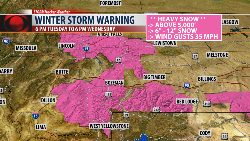
The National Weather Service continues a Winter Storm Warning for Madison, Gallatin, and Meagher Counties from 6 pm Tuesday to 6 pm Wednesday. The Absaroka/Beartooth Wilderness is also under a Winter Storm Warning.
Snow accumulations will be higher above 5,000′ with 6″ – 12″ possible.
Mountain passes impacted: Bozeman pass, Horris Hill and Targhee pass.
Bozeman is NOT included in the warning.
_________________________________________________________________________________________________________
WINTER WEATHER ADVISORY

The National Weather Service has a WINTER WEATHER ADVISORY up for the Butte/Blackfoot region and for Jefferson County of SW Montana from 6 pm Tuesday to Noon Wednesday.
Snow accumulations: Valleys 2″ – 4″ and mountain passes 4″ – 8″
This includes Butte, Anaconda, Deer Lodge, Georgetown Lake, MacDonald pass, and Homestake pass west of the divide. I-15 Elk Park to Boulder.
________________________________________________________________________________________________________
SNOW FORECAST


Forecast models continue to struggle with possible snow accumulations from model run to model run. This is a complex storm system with great potential for snow due to the slow movement to the East over the next 24 to 48 hours.
Snow accumulations should be minor for most valleys and heavier across all mountain ranges and mountain passes. The bottom line is slushy snow will bring slow go travel tonight and Wednesday for most valleys and especially for mountain passes.
This snow should melt away by Thursday and Friday and could lead to minor flooding issues.
City by City Forecast:
BOZEMAN: LOW: 28°; HIGH WEDNESDAY: 36°. Colder tonight and Wednesday. Valley rain or snow is likely up to midnight but should be mostly snow by Wednesday morning. Bozeman could see a couple of inches of snow by Wednesday evening. Heavy wet snow is likely above 5,000′ and Bozeman Pass could see 6″ – 12″ of snow over the next 24 hours. Wednesday morning commutes will be impacted by this storm.
BUTTE: LOW: 25°; HIGH WEDNESDAY: 37°. A rain-snow mix is possible for the early evening hours tonight but mostly snow is likely after 10 pm through Wednesday afternoon. Butte could see 2″ – 4″ of snow and nearby mountain passes will likely pick up 4″ – 8″ and this includes: Homestake pass, MacDonald pass, and Georgetown Lake.
DILLON: LOW: 27°; HIGH WEDNESDAY: 38°. Tonight look for colder temperatures, gusty winds and rain or snow for Dillon. Wednesday morning will favor mostly light snow accumulations for Dillon. Mountain passes will see periods of moderate to heavy wet snow tonight through Wednesday evening. Snow accumulations greater than 6″ is likely for Chief Joesph pass, Monida pass, and Big Hole pass.
WEST YELLOWSTONE: LOW: 34°; HIGH WEDNESDAY: 62°. Rain will change to all snow tonight and Wednesday for the West Yellowstone area and inside Yellowstone National Park. Snow accumulations are likely with lower valleys picking up several inches but most mountains above 5,000′ could see 6″ – 12″ of heavy wet snow. Gusty winds are also likely tonight and Wednesday.
