
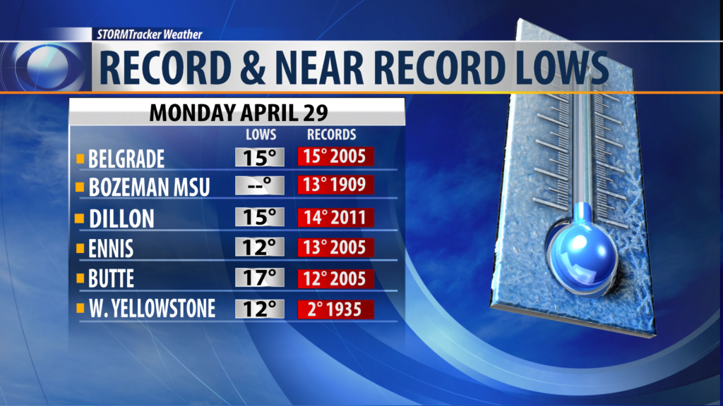
BOZEMAN – Unseasonably cold temperatures for late April impacting Montana this past weekend and into the first several days of this week. Record and near record lows for SW Montana Monday morning with early morning temperatures dropping down to the teens and 20s.
NEXT WEATHER MAKER
A trough continues to sit over Montana with a weak Low over central Idaho Monday afternoon and this storm system will bring increasing snow and wind to the region overnight through Wednesday morning.
Snow is likely across SW Montana with mountains and passes picking several inches of snow tonight through Tuesday night. Travel impacts are likely especially for mountain passes in our region over the next 24 to 48 hours. Valley snow should be on the light side but with these cold temperatures, minor snow accumulations are possible.
This trough and Low will also produce stronger surface winds tonight and Tuesday. This will bring areas of blowing snow and colder feels like temperatures Tuesday.
WINTER WEATHER ADVISORY
UPDATED!
Additional counties have been added to the Winter Weather Advisory and now includes all counties in SW Montana both west and east of the divide tonight into Tuesday afternoon.
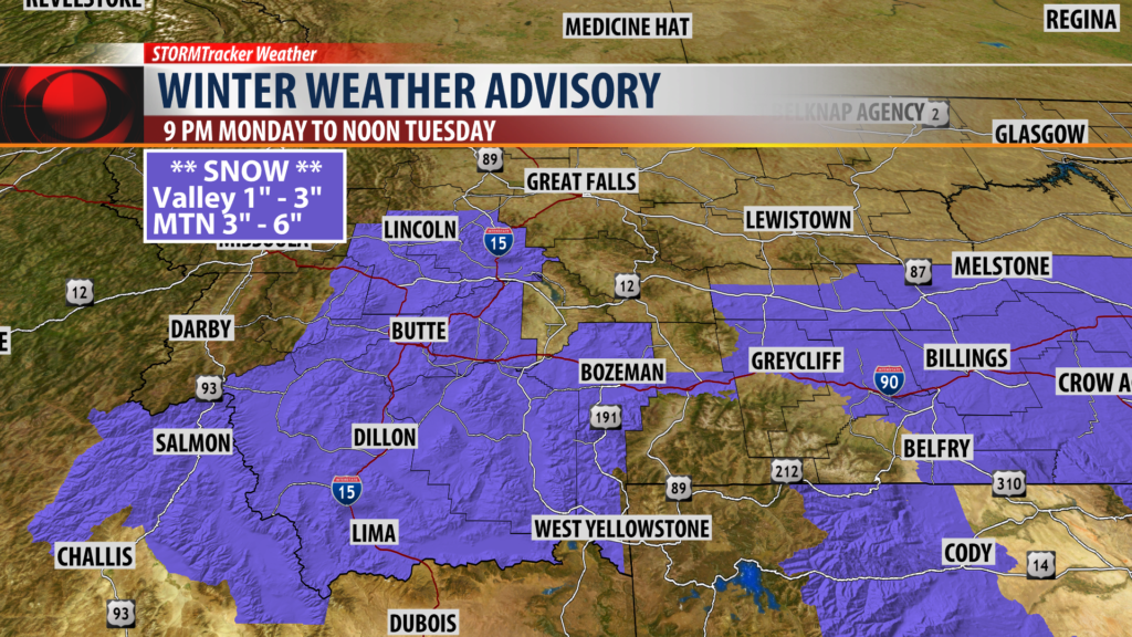
The National Weather Service has a WINTER WEATHER ADVISORY for travel impacts for SW Montana.
Snow accumulations of 3″ – 6″ is possible for mountains and passes with 1″ – 3″ for lower valleys. Gusty surface wind over 30 mph is also possible at times.
WINTER STORM WARNING

The National Weather Service has a WINTER STORM WARNING up for the Absaroka-Beartooth wilderness region near Cooke City this afternoon through Wednesday morning.
Higher elevation snow of 10″ – 14″ is possible and with gusty winds look for wind loading and increased avalanche danger in the backcountry.
City by City Forecast:
BOZEMAN: LOW: 22°; HIGH TUESDAY: 38°. Continued cold with areas of light snow overnight and during the day Tuesday. NE winds 5 to 15 mph and gusting at times to 30 mph. Snow accumulations of 1″ – 3″ is possible.
BUTTE: LOW: 20°; HIGH TUESDAY: 36°. Cold temperatures to stick around tonight into Tuesday. Snow showers are likely with 1″ – 3″ possible by Wednesday morning. NNE winds will be increasing 10 to 25 mph and gusting to 35 mph at times.
DILLON: LOW: 23°; HIGH TUESDAY: 38°. Cold again tonight and into Tuesday. Scattered snow is possible with light accumulations for Dillon but nearby mountain passes could pick up 3″ – 6″ of snow. NE winds 15 to 25 mph and gusts to 35 mph are likely.
WEST YELLOWSTONE: LOW: 16°; HIGH TUESDAY: 37°. Increasing snow overnight and into Tuesday with scattered snow ending by Wednesday morning. Snow accumulations of 3″ – 6″ is possible. North winds will be increasing 10 to 20 mph tonight and into Tuesday.
