


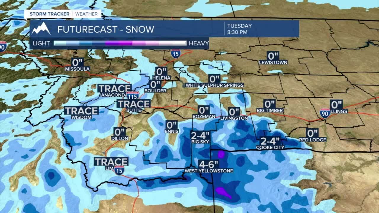
Today's Forecast: Scattered showers with daytime highs hovering in the 40s. Showers are likely to involve light snow or a rain/snow mix with late-afternoon rain showers. Our showers will be scattered across the region and will slowly fade from northwest to southeast as we move toward the afternoon. Snow will be heaviest across the southern mountains in southwest Montana leaving 3”-6” of wet snow in the Gallatin and Madison ranges as well as in the Absaroka-Beartooth Mountain range.
BOZEMAN: High: 47; Low: 24. Scattered rain/snow showers are expected through the late morning and early evening before skies clear and showers taper. Winds will stay out of the southwest between 10-20 mph with gusts near 25 through the afternoon and evening. Overnight temperatures will fall quickly back to the middle 20s.
BUTTE: High: 41; Low: 19. Look for a mix of rain and snow for the morning and early afternoon. Winds will stay out of the southwest for the afternoon and shift more out of the northwest between 10-20 mph with gusts approaching 30 mph. Showers will taper for the afternoon with clearing skies during the evening.
DILLON: High: 47; Low: 23. Cool and windy with a few spotty showers. Winds will be out of the west to southwest between 15-30 mph before skies clear during the afternoon.
WEST YELLOWSTONE: High: 42; Low: 16. Expect mostly cloudy skies before spotty snow showers take over during the afternoon and evening as we see accumulations pick up toward the evening. Snow totals will likely stay between 2”-4” with as much as 6” possible.
SHOWERS INCLUDING SNOW FOR THURSDAY THROUGH SATURDAY: Another cold air mass will move into the region late this week that will bring in a moisture-rich mass of air. The system will be a Pacific system that will pack cooler, but not arctic air. Temperatures in southwest Montana will stay in the 40s. This system will pack the mountains with a fair amount of fresh and wet snow, which will help the snowpack in southern Montana. Eastern Montana will likely see heavy snow through Sunday as they pick up another round of heavier snow.
The latest model runs for Bozeman have come down considerably. Previous forecasts indicated as much as 3”-6” possible. The latest runs are more on the order of 1”-3”. The model spread is more dramatic than other portions of southwest Montana, which indicate that temperatures during this timeframe are more uncertain. If temperatures drop, those snowfall numbers will come up.

For Butte, the numbers are more consistent and show more of a 1”-3” range. The models show that the upper-level low will move farther to the south which should keep the snow totals from making any sharp jump.

West Yellowstone forecast is where we see the biggest jump in snow. The total range Friday evening through Saturday morning range between 4”-8” inches of snow with a high snowfall closer to 10”. This all comes after snow Tuesday into early Wednesday of between 3”6”.

This next storm is several days out, but the models do indicate significant snowfall in the region. We will have more concrete numbers as this storm evolves and moves closer to the west coast out of the Gulf of Alaska.
